Here’s why the South Pole froze over before the North Pole


Read a summary of this article on FAST.
Get bite-sized news via a new
cards interface. Give it a try.
Click here to return to FAST
Tap here to return to FAST
FAST
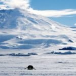
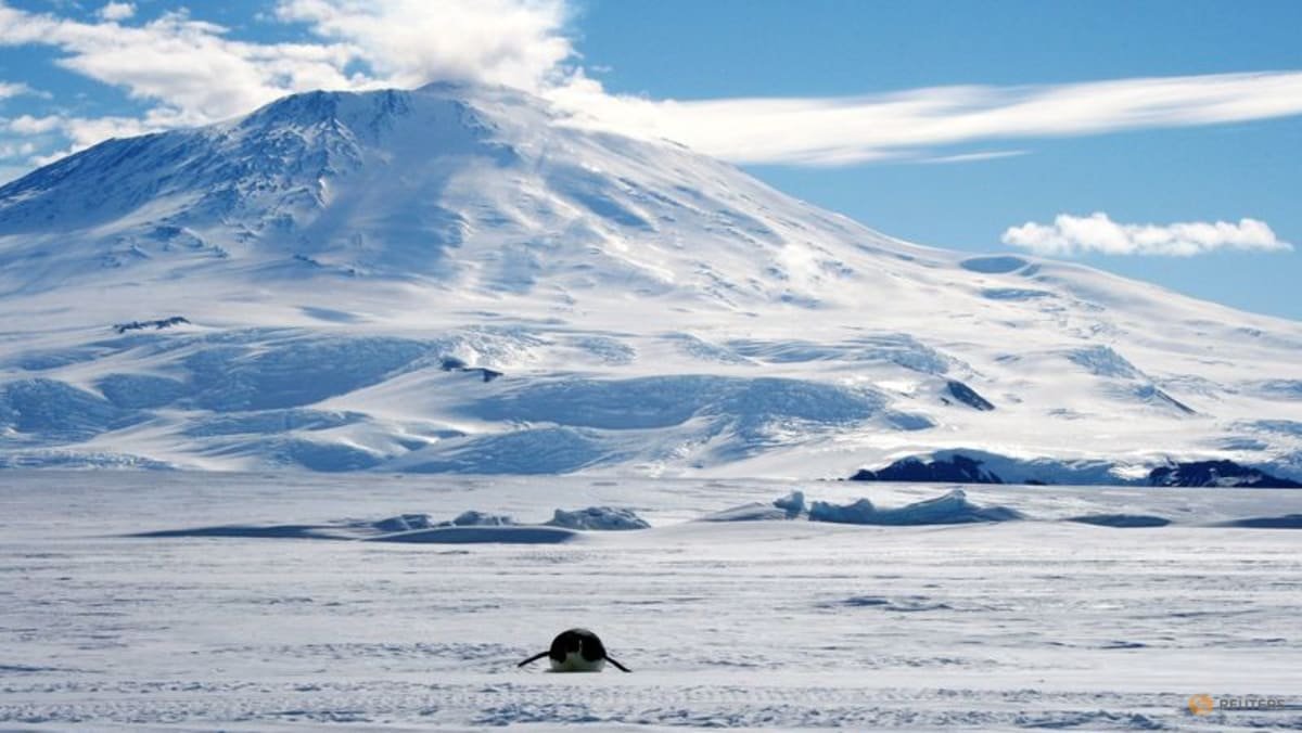
July 2 : While it once was temperate and lush, Earth’s southernmost continent Antarctica froze over about 34 million years ago, covered by an ice sheet that today is up to around 3 miles (5 km) thick. By contrast, the planet’s northernmost realm, the Arctic region, did not freeze over for another 25 million years.
This polar asymmetry long has puzzled scientists, but researchers now may have solved the mystery.
They assessed the Antarctic region’s topography and used computational models to reconstruct how the surface evolved over many millions of years. They found that a powerful geological process drove the renewed uplift of a mountain range in eastern Antarctica that eventually passed an elevation threshold crucial for letting mountain glaciers form and expand and for permanent ice to take hold.
The result was the appearance of the vast East Antarctic ice sheet at a time when global temperatures were around 9 degrees Fahrenheit (5 degrees Celsius) warmer than today. That left the South Pole with an ice cap long before a long-term global cooling trend enabled an ice cap to become established around the North Pole. The East Antarctic ice sheet was in place by the start of a chapter in Earth’s history called the Oligocene epoch, which followed the Eocene epoch.
![]()
Guess Word
Crack the word, one row at a time
![]()
Buzzword
Create words using the given letters
![]()
Mini Sudoku
Tiny puzzle, mighty brain teaser
![]()
Mini Crossword
Small grid, big challenge
![]()
Word Search
Spot as many words as you can
Antarctica once was part of a Southern Hemisphere supercontinent called Gondwana that also included landmasses that are now Africa, South America, Australia, Arabia and the Indian subcontinent. As part of a process called plate tectonics involving the inexorable movement of continent-scale plates on the planet’s surface, these landmasses eventually separated and crept toward their current locations.
“Our study shows that an ancient geological process that started more than 160 million years ago during the continental breakup of Africa and Antarctica and played out over many tens of millions of years determined when and where Earth’s major ice sheets could form during the Eocene-Oligocene transition, approximately 34 million years ago,” said geoscientist Thomas Gernon of the University of Southampton in England, co-leader of the study published on Thursday in the journal Science.
This transition marked the change from Earth’s warm “greenhouse” climate to the current cooler period, Gernon said.
Antarctica remained connected to Australia and South America for tens of millions of years after Africa drifted away, eventually separating from those as well.
The geological process Gernon mentioned is a phenomenon called mantle waves — slow-moving disturbances deep within the Earth that are triggered during continental breakup.
“These waves can remove dense rock from the underside of tectonic plates, making the continents lighter and causing them to rise, ultimately forming high ground such as plateaus and mountain ranges,” Gernon said.
When these mantle waves moved under Antarctica, they caused the formation of a large plateau topped by the Gamburtsev Mountains, a range in the central part of eastern Antarctica. While these mountains reach up to about 11,120 feet (3,390 meters) tall, the range is now buried under the world’s largest ice sheet.
The researchers said the erosion and uplift caused by mantle waves gradually pushed the landscape to elevations high enough for ice to stabilize, even at a time of a warm global climate.
CLIMATE AND TOPOGRAPHY
“Our study underscores the importance of the interaction of changing climate and changing topography,” University of Southampton geoscientist and study co-leader Thea Hincks said.
For Antarctica at the end of the Eocene, the elevation threshold for facilitating permanent ice was roughly between about 4,920 feet and 6,560 feet (1.5 km to 2 km), Gernon said. The study’s simulations indicated that by around 45 million years ago, large areas of the eastern Antarctic landscape had ascended above this threshold.
“Just as temperatures fall as we climb a high mountain, higher elevations are more likely to retain snow year-round. We found that before Antarctica became glaciated, the area of the Gamburtsev Mountains above the critical elevation for sustaining ice increased dramatically. By about 34 million years ago, nearly 90 per cent of the region lay above this threshold, compared with only about one-third 60 million years ago,” Gernon said.
The situation differed in the Arctic, where glaciers waxed and waned over the past 50 million years but large ice sheets did not stabilize until less than 10 million years ago. There is no actual land at the North Pole. It is situated in the middle of the Arctic Ocean. That means there was no terrain to reach the elevation threshold earlier to foster permanent ice.
“The climate needed to get cooler via reduced atmospheric carbon dioxide concentrations before permanent ice could form at lower elevations,” Gernon said.
Source: Reuters
Sign up for our newsletters

Get the CNA app
Stay updated with notifications for breaking news and our best stories
Get WhatsApp alerts
Join our channel for the top reads for the day on your preferred chat app
![]()
Get bite-sized news via a new
cards interface. Give it a try.
Click here to return to FAST
Tap here to return to FAST
FAST